Day 13 Newhaven and Edinburgh Saturday, Sept 23, 2017
Our excursion, chosen from nine offered by the cruise line, was called A Walk on the Royal Mile and Holyroodhouse Palace. Here I am at the top of the Royal Mile, in front of Edinburgh Castle. Even though the tour began near here, we had to walk back here later in the day, after our tour, to get this close.
Our ship had to anchor a long way out in Newhaven's harbor, and we came in via this shuttle.
As we walked onto the pier, there were a bagpiper and drummer to entertain us, but no one could get a picture of only them because the various Asians followed their pattern of taking a million photos of themselves posing with whatever they could pose next to. In the background, Janet is amused by this common occurrence.
When we arrived at this tiny harbor, it was low tide and all those boats were sitting in the mud. There was barely enough water for our shuttle to enter through the harbor walls. For contrast, here is the photo I took eight hours later when we returned to the ship:
They certainly have to plan ahead when they wish to use their boats from this harbor!
Our bus dropped us off on the street below the Royal Mile, and the guide said this was the best we would see of the castle because they were removing the grandstands (see the upper right of the photo) from the recent annual Royal Edinburgh Military Tattoo, part of the Edinburgh Festival. It was attended by over 220,000 spectators, begun in 1949. Those temporary grandstands hold 8600 people.
We learned during our short bus ride here that Edinburgh is Scotland's capital, and has a population of 465,000. Both the Old Town (on the hill), and the New Town built during the 18th and 19th centuries over a "cesspool" (north of the hill toward the bay), are UNESCO World Heritage sites.
The Royal Mile stretches from the castle down one mile to the royal palace at the other end. It includes five distinct streets, Castlehill, Lawnmarket, High Street, Canongate, and Abbey Strand. We completely skipped Castlehill due to time constraints and the grandstands removal, but Janet and I skipped the bus back to the ship following our tour of Holyrood Palace and saw it later in the day.
Once we were done using the restrooms and finally ready for our walking tour, we left the main street and walked down an alley (a "close") into the courtyard in the photo above.The building here is Lady Stair's House, and it's now The Writers' Museum dedicated to Scotland's most illustrious writers, Robert Louis Stevenson, Sir Walter Scott, and Robert Burns.
See that plaque on the wall in the photo above?
It says that Lady Stair's House was erected in 1622, and was restored by Lord Roseberry in 1897.
On the far side of the courtyard was this seven-story apartment.The guide explained about the social stratification in early times,
and how in apartments like this one, the various
social classes shared the same urban space. A form of social segregation
still prevailed, however, whereby shopkeepers and tradesmen tended to
occupy the cheaper-to-rent
cellars and garrets, while the more well-to-do professional classes
occupied the more expensive middle stories. Apartments as early as the 16th century got to be as high as 11 stories!

We proceeded back onto the main street and I enjoyed the appetizing appearance of Deacon Brodie's Tavern. So many floral arrangement and character; it was just the first of hundreds of attractive pubs we saw before we would leave London. This pub, however, has an illustrious back-story. Deacon Brodie (1741-88) was a cabinet-maker and city official by day, but a notorious robber by night, with "an appetite for drinking, gambling, and womanizing." He was finally caught, convicted, and hung on this spot where the tavern now lies. He inspired Stevenson's
Dr. Jeckyll and Mr. Hyde.
Our tour guide was trying to explain a statue where I'm standing, but the fellow playing the bagpipes for donations was so loud, we couldn't hear her. So here she is giving him a big tip and asking if he would therefore stop for a minute while she spoke to her group. He nodded yes, and a thank-you, but he never paused in his "noise." So, our irritated guide had to shout to be heard.
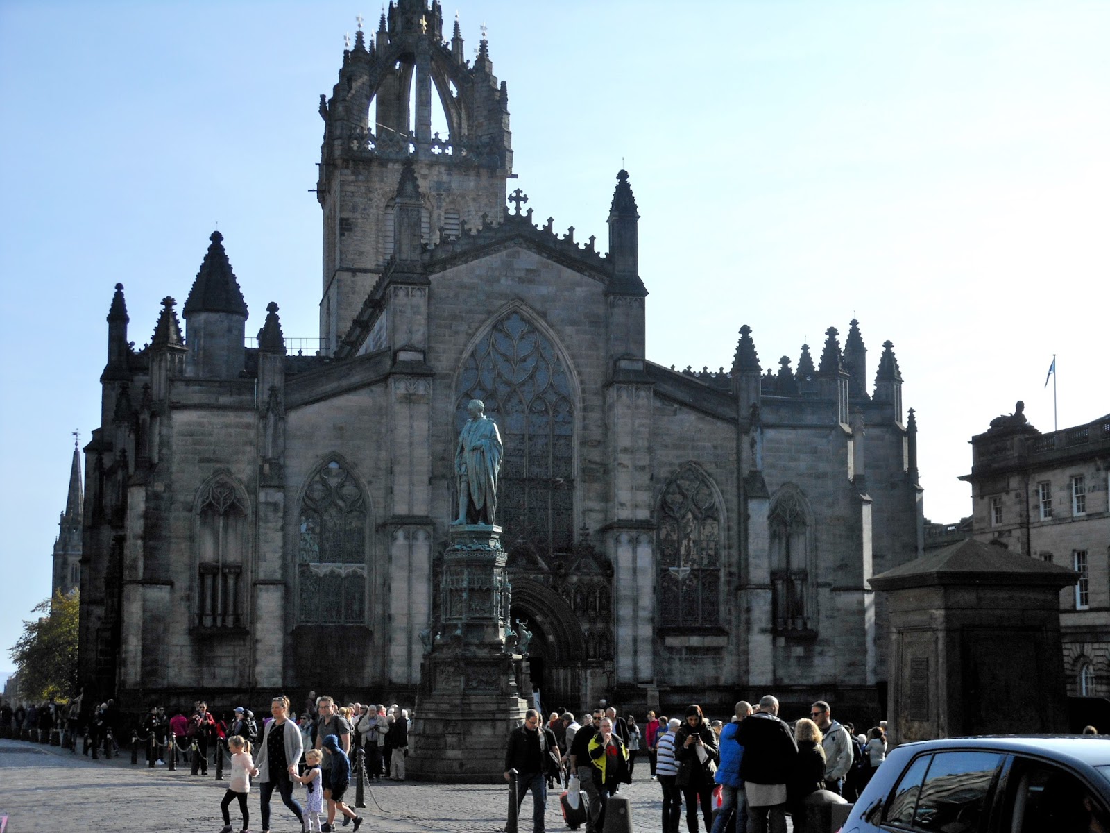
A bit further down, where Lawnmarket and High Street meet, is St. Giles Cathedral. Originally a Norman church was built here in 1120, but the current church, with its crown steeple, dates from late 14th century. It is known as the home of Presbyterianism, where John Knox ignited the Scottish Reformation. (Since it's not Catholic, locals prefer to call it by its other name, The High Kirk of Edinburgh, which omits "cathedral". It's actually just a parish church.)
St. Giles' elaborate front. We toured inside (no photos allowed), getting to see the magnificent stained glass windows and arched ceilings.
As we continued down the street, we got to where they sometimes create a pedestrian-only section, between here and the castle. You can see barriers (open this day) and also the security passages where they occasionally use X-ray or other security measures, depending on the event occurring farther up the street.
I decided to take a picture of the attractive tourist in blue, since I hadn't yet gotten her in a single photo that day!
Our guide stopped to tell us that this close (alley) led to the Royal Mint (1574-1877), and therefore many prominent citizens lived back down there.
Immediately next to South Gray's Close was this, "the noisiest museum in the world" due to all the kids and their parents in there. It's the world's first to specialize in the history of childhood.
I don't know what it is, but it sure looked fancy. I loved the headlamps, where the rear-view mirrors are placed, and the ribbon wrapping from the windshield to the hood ("bonnet") ornament.
The John Knox House is a Royal Mile highlight. It has remained largely unchanged since 1550 when the family who were Mary Queen of Scots' goldsmiths lived there. That thing in the middle (above the man's head) is a sundial of Moses pointing to the sun. Many doubt that John Knox ever lived here, though. The interior is highly decorated with painted ceilings, and it contains relics of Knox and the Reformation.
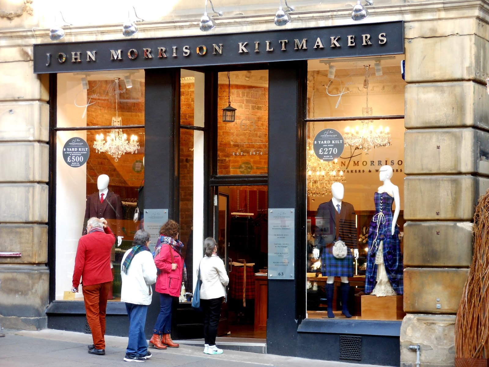
We saw many kiltmaker shops. Janet kept asking me if I wanted one of those skirts to wear.
Yet another attractive pub, this one named High Street, on High Street (on Royal Mile).
I don't remember what building this was, but we liked the roof, turrets, and clock.
Canongate Kirk, from 1668, was built by a preacher who had been expelled by the old Holyrood Abbey. Thirty years later, King James VII (James II of England) decided to make it a royal chapel. The royal family worships here when they're in town.
Janet and I toured inside Canongate Kirk when we returned up the street later. The interior was simple but elegant, and had lots of royal mementos and photos (in the entryway) of the current royal family.
Almost to the end of the Royal Mile, inside a short alleyway, was this White Horse Close. Our tour guide walked us in here, but so many huge tour groups kept passing by that we couldn't get much from her. Originally, this area was the palace stable, and named for Mary Queen of Scots' favorite horse. From the 17th century to 1889, it was an inn which served as the coach terminus for journeys between here and London. After 1889 it was completely rebuilt as a workers' residence, and was rebuilt into its current style in the 1990s.

The final site on the Royal Mile, before Holyrood Palace, was the new parliament building, dedicated by the queen in 2004. From the outset, the building and its construction were controversial. The choices of location, architect (a Catalon), design, and construction company were all criticized by politicians, the media, and the Scottish public. Our tour guide seemed to like it, and explained that the design incorporated many different aspects of Scottish history and culture. Yet, one of the men on the tour was loudly criticizing it to others within his earshot, saying that a parliament building should look like London's parliament. Sigh. After it opened, it won many architectural awards.
Holyrood Palace! The fountain, and clock over the entry, were "regal." We were all given audio packs to explain everything as we toured the palace, and we could go at our own speed. No photos allowed.
It's the official residence of British Monarchy. It's been the official residence of all Scottish kings and queens since the 16th century. Queen Elizabeth spends a week there at the beginning of every summer, carrying out official ceremonies and engagements. It's pretty darned big - 70 meters long and 70 meters wide. Most current structures were built to celebrate when King Charles II restored the monarchy following Oliver Cromwell's downfall in 1660.
I snuck this photo out one of the interior windows, thinking it should be okay since I wasn't photographing anything inside. We went from one elaborate room to the next, listening to all sorts of history and stories and information. We saw King X's this, and Queen Y's that, and on and on. Mary Queen of Scots seemed to be the biggest la-de-dah they ever had there. "Queen Mary slept here," literally, as they had her bed on display.
In the Great Gallery, they had on display portraits of all 110 of the Scot Kings and Queens. Even Bonnie Prince Charley held evening balls in the gallery during his short occupation. While we were there, a tour guide was giving a pretty detailed history of Mary Queen of Scots and why she was executed by Queen Elizabeth I.
We could take pictures again outside in the old Abbey, founded in 1128 by King David I. The Abbey was used as a parish church until the 17th century, and has been ruined since the 18th century. Scotland's parliament met there during the 13th and 14th centuries.
There's Janet admiring the columns and carvings along the top. The Abbey has graves of many famous people, including Adam Bothwell (died 1593), surely an ancestor of John.
One of many carvings on the Abbey's upper wall. Seems to have survived the elements pretty well over the past 300 years.
This is the old entrance to the Abbey, which we saw as we were leaving. Elaborate carvings, but eroded a bit after all the years. The walls of the newer palace abut against it on the right.
We then told our tour guide we would not take the bus back to the ship, but would walk some more and take public transportation. No problem, she said. Just take Bus 16 on Princes Street, she said. That turned out to be wrong.
First thing to do on our own? Lunch! It was the first time on this trip we were paying extra for our lunch. We had passed the Oink on our way down the street earlier, and decided to give it a try. Janet is standing next to the window with...
...the entire pig! I had the Oink and Janet had the Piglet. We were lucky to find a seat, it was so crowded and not very big inside.
But we did find a spot, and it all tasted yummy. Those beers are named Edinburgh Gold and Hollyrood (not Holyrood!) Pale Ale.
After lunch, we headed back up the Royal Mile to explore places we had to hurry by earlier, as our guide walked pretty fast when she was trying to get to the next place to talk to us. This mural and cow statue were pretty colorful (behind trash bins!).
This open-air market was just off the main street, with performers, food, drink, and crafts. Off in the distance is Calton Hill, and the monument on top is the Admiral Horatio Nelson Monument (1816).
This was Cockburn Street, and curved on down to New Town below. We walked a little ways down, until we came to...
...Miss Katie Cupcake. Here's another view of the main entrance:
We liked the bicycle with the flower basket in front. (I'm typing this on Katie's birthday).
This was the long and steep close (alley) to return to the Royal Mile. These closes were all along the main street, to allow people to reach the courtyards behind where the residential apartments were located.
Several shops sold these horn drinking mugs, which looked cool. Wouldn't want one, but they were interesting. It says "Game of Thrones Mugs" on the tag, so perhaps someone who watches that show would recognize these. Are they from Longhorn cows?
As we continued back up the Royal Mile, we reached Castlehill Street which we had missed earlier. The photo above shows a magnificent church, but it's no longer a church. It's now called The Hub, but has had many names. It was built in 1842-45 and called Victoria Hall. It ceased being a church in 1928, and was renamed Tolbooth-Highland-St. John's in 1956. It was completely closed between 1979-99, and then opened as The Hub, with office spaces and performances halls. Our tour group had actually gone in there first thing when we got off the bus, so everyone could use the rest rooms. Its spire is the highest point in all of Edinburgh.
We laughed at this, because it's now a big store all about whisky, but you can see at its top that it used to be the Castlehill School. Ah, how better to use a school, which they apparently no longer need? haha
We eventually made it back to the upper end of the Royal Mile, with the castle behind me. But we were running too low on time to be able to tour the castle.
One last shot of the castle, in addition to the one at the very top of this posting, with me in it. We'll have to tour this the next time we come to Edinburgh. It's supposed to be super inside
At this point, it was time to walk down into New Town to catch the bus to the port.
As we walked down, we thought this apartment and small street were an inviting spot to live.
We were about halfway down the hill when I took this picture. Out there is New Town, which used to be essentially a cesspool. Prior to mid-18th century, it was sort of a lake, serving as a protective moat for the city on the hill above. But people dumped their sewage there, and it became a horrible cesspool. Since the population had grown and they needed to expand the city beyond the hill, they planned out New Town and built it from about 1767 to 1850. It is considered to be a masterpiece of city planning (a grid).
In the photo above, you see the Sir Walter Scott Memorial (1846) on the left, and the Balmoral Hotel (1902) on the right, considered city landmarks.
We reached New Town and were crossing a bridge over what used to be the lowest point in the moat before they cleaned it all up. Of course, we also see the Scott Memorial and Balmoral Hotel again. New Town officially begins with Princes Street on the left, where we were told to get our bus.
That's it for my photos for the day, other than the one I showed earlier of the high tide in the little harbor where we caught the shuttle out to the ship. The story of what happened from this point to getting back to the shuttle boat was that we had a heck of a time finding the correct bus. We seemed to be on a wild goose chase part of the time, realizing that asking locals for help with bus lines other than the one they are used to taking themselves, is not a wise strategy.
A bus driver finally told us we needed to walk farther up a couple of streets, but even that was not clear to me, and I got us lost again. With us were several others from the Jade who also were trying to find the correct bus, but they went off in their own direction. Finally when we got onto the correct bus, the other Jade passengers were on it already. So, we finally made it back, reached the little harbor, got a shuttle, and cruised way out to the anchored ship.
This ended all our cruise excursions, and it's hard to think we could have enjoyed them all any more than we did. As my LONG blog entries show, we saw, learned, experienced, and loved everything we did in the interesting cultures and histories of Norway, Iceland, and Scotland.
We looked forward to a "day off" at sea for our final day of the cruise. We needed to rest up for a week of London!