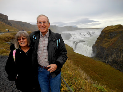
Exciting Gullfoss, Europe's largest waterfall. This photo doesn't show how far the final drop is into the canyon on the right of the picture (see later photos below). From this vantage point, you could not see the river below, so it was strange to see the water dropping into "nowhere". Today's all-day tour focused on Iceland's geological features, and was fascinating. The places we visited were called The Golden Circle, described in their publications as: "Explore the island's raw and rugged interior."
Our first stop was the UNESCO site, Thingvellir National Park. It's famous for a few reasons: 1) continental drift -- the North American and Eurasian tectonic plates continue to split apart from each other here, creating deep fissures and canyons; 2) Iceland's parliament, the oldest in the world, met here beginning in 930 AD; and 3) the lake and rivers are quite scenic.

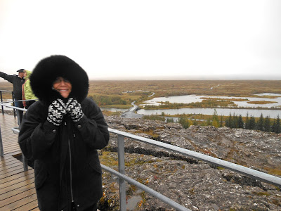
I wanted to start by showing the view to the north, the large lake. The tectonic plate boundary is in the distance, but shifting occurs all over, including where our tour walked from the parking lot.
This photo is in the other direction (toward the south). There's a flag pole (no flag though) about 200 yards away, which is where the ancient parliament (Althing) gathered to hear 48 chieftains discuss laws & engage in court proceedings on behalf of the country’s citizens. Regular people also could step forward and give speeches about important matters. Althing continued here for 868 years, from 930 to 1798. Our tour guide said that sometimes it would take several days to recite a new law (it was all from memory, too, as they had no written language yet). Janet and I could not imagine sitting there for days listening to someone recite the details of a new law.
Two similar photos above, with an interesting story (one photo includes Janet, and the other shows how deep the ravine is). The tour guide told how when he was a boy, his family had day trips here and would drive their car right through this ravine where we are standing on this bridge. Prior to 2011, this was a gravel road leading into the valley below. But in 2011, they noticed a small hole in the road.
I took this photo of the board explaining what happened. See that small hole? They banged the hammer around and it kept exposing a larger and larger hole. It turned out the gap below was 30 feet deep and 45 feet long! They think it began during the earthquakes of 2000 and 2008, and then eroded away from rain and snowmelt. They had to build the current wooden bridge to allow visitors to still reach the valley below.
This photo looks straight across the valley (westward, in the direction of Reykjavik). The tectonic plate boundary is a dark streak on the other side. Farther to the south, where we would visit later in the day, the plates inch past each other (the final photo in this entry shows this). But here, the plates break apart and the land between subsides. Away from the plate boundaries, the activity is fairly constant, about an inch per year; however, in the rift zones themselves, tensional stress accumulates during a long period and is then released in a burst of activity when fracture boundaries are reached. The most recent burst of activity swept over Thingvellir in spring, 1789 (just as George Washington began his first term as president).
The river in the photo above flows to the south (to the left) to a gorge called Silfra, where scuba divers explore the gap between the two tectonic plates.
I stole this photo from the Internet, but as our tour bus was headed away from the national park, we saw Silfra's parking lot full of cars and SUVs. Our guide said this was a popular diving spot because it's the only place in the world where you can dive between two continental plates. The cold glacier water is extremely clear.
Our next stop was Haukadalur, an active geyser area. On the bus ride there, we saw and learned about Icelandic horses, which are a hearty, separate breed developed from ponies taken there from Norway in the 9th and 10th centuries. They have few diseases; Icelandic law prevents horses from being imported into the country and exported animals are not allowed to return.
I stole this photo from the Internet. They are short, like a pony, and stocky (reminded us of the Shetland ponies). Selective breeding over the centuries has developed the breed into its current form, although natural selection has also played a role, as the harsh Icelandic climate eliminated many horses through cold and starvation.
Both our tour guide that day, and our guide the next day in Akureyri, proudly told of a special characteristic the horses have - an unusual gait, called the tölt. One leg is always on the ground, allowing a smoothness of the gait. They hold "beer tölt" competitions, whereby the riders are known for not spilling a drop of beer from their mugs as they gallop along.
Back to the geysers. There were steam pots everywhere, but if you took a short walk, you could stand next to their own version of Old Faithful, called Strokkur. There was a 2nd famous geyser here called Geysir, after which the general term “geyser” was named. (The original Geysir no longer erupts after an earthquake shut it down.)
Here is Strokkur erupting 100 feet up, which happens every 8 to 10 minutes. I stole this photo from the Internet because I could not get a suitable photo during the two eruptions we witnessed up close (see those spectators in the photo? That's how close we were.) You could see that the eruption was about to happen because huge bubbles would surge up and down just prior. Our guide would say "Here it comes!" But it occurs and ends so quickly, I couldn't get my camera shutter to snap at the precise moment. It sure was exciting to experience!
Just one of many boiling pots as we walked to Strokkur and back.
Our next stop was Gullfoss, the two-tiered, 105-foot waterfall on the glacial Hvítá River. To get this close to the falls, you descended 94 steps from the parking lot and restaurant, where we ate lunch.
To get this close to the falls, you needed to walk about 400 yards farther, which Janet elected not to do with her sore ankle. If it had been sunny, we would have gotten rainbows.
I like this photo because it finally shows how far down the falls drop, into that narrow ravine. The tour guide said that in periods of flooding, the amount of water can be 10 to 12 times greater than it was here, almost completely filling that ravine.
Our salmon and cream of asparagus soup lunch was fabulous, served family style in the restaurant next to the visitor center. The Chinese man next to Janet kept reaching across in front of her to get more food from the food plates. Janet would offer to pass him the plate, but he would indicate "no thanks", but then reach across her to get it anyway. Differences in cultural habits! We also thought it was a bit "different" for the Indonesian woman across from us ask to have her American husband's salmon membrane to eat, which the rest of us discarded.
We learned about the 11-yr-old girl, back in the early 20th century, who so opposed the idea of building a huge hydro-electric generating plant there, that she walked to Reykjavik several times to protest the idea, and even threatened to throw herself off the falls if they moved ahead with their plans. The plan actually failed due to lack of money, and the falls were soon sold to Ireland to forever preserve them in their natural state. But the story of little Sigríður Tómasdóttir lives on, and there's a stone monument to her above the falls.
Our final stop was in the town of Hveragerdi, near the south coast. It's a famous geo-thermal spa area, but we visited an earthquake exhibit. In May, 2008, a 6.3 earthquake struck near here, and they re-created what people's kitchens and grocery-store shelves looked like afterward. To me, it looked exactly like what my own kitchen looked like after our Simi Valley 6.6 earthquake in 1994. "No big deal" to see this exhibit if you went through an experience of your own like that!
But to me, the photo above was the most interesting part. It turns out, the continental-plate rift went right through the floor of the earthquake exhibit! They put glass over the gap, which was about three feet deep. This is the part of the rift where the plates shift consistently about an inch each year, not where big shifts occur. Thus, they can put glass over it like this in the floor.
Our guide told interesting stories and provided Icelandic info all during the day, so we truly enjoyed The Golden Circle (even though the tour began at 6:45 am! Oh, how cruel it was to have our alarm go off that early in the morning. And we got a laugh when Janet yelled out to ask if I was in the bathroom, not realizing my ear was right next to her. Coming out of her deep sleep and without her coffee yet, Janet cannot be faulted for failing to notice a body next to her. lol)


No comments:
Post a Comment